I charged up my batteries yesterday morning, planning to take a ride and test out my range. While charging, I decided to do a little clean up in the garage. I got more ambitious as I could see the fruits of my labor and ended up spending most of the afternoon clearing out junk and organizing. By the time I was done, it was late afternoon, so I decided to squeeze in a short ride instead, by taking a ride down to the bay and check out the sunset.
Perfect weather for riding, a little on the cool side, perfect for a pullover sweatshirt. Looked to be lining up for a spectacular sunset.

I saw an article that they'd opened up a new section of the path/trail along the bay, so since it was still light out, I tried it out. It runs on the water side of the Golden Gate Fields horse racing track, with two nice lookout spots. The nicer one had a couple seated on the bench, waiting for sunset. I stopped on the next one, that still has nice view. It's a decent climb up to the lookouts, but not an issued with electric assist.

The sun was still up, so I decided to keep riding...for a while. I ended up three towns over, near the Bay Bridge. My original plan for the day was to ride up the bridge to Treasure Island in the middle of the bay. From that spot, it would only be 4 or 5 miles to the island. I might be able to make it, and still get home without having to use my headlight, so I went for it.
Weather was nice, but the wind was brutal. 15-20mph direct headwind for 90% of the climb. I was pedaling hard, and pulling about 850 watts the whole way up because of the wind. Forgot to mention that I did my whole ride on the low position of my 3-speed switch, since it was a range test. There's only one tower on the east side of the bridge, about a 1/4 mile from the island.


I didn't have time to ride around the island like my original plan, so I just touched the island and turned back. I peaked over the edge of the bridge to take this shot of the island; The island is actually two islands, Yerba Buena, the natural part, and Treasure Island, the manmade part, built for the World's Fair long ago. This the the Yerba side.

Sun was starting to get low, and I had about 15 miles to go.

At least the path was clear virtually all the way back. Nobody was headed toward the island by that time.

Would have been perfect for a top speed test, except for that darn speed limit! :lol:

Anyway, I'll start out earlier next time, since I wanted to check out the status of the $5 billion condo complex that was under construction on the island, recently stopped due to a class action from the existing island residents.

Final energy per mile: 23.0Wh/mile
EDIT: 10-29-20 - I realized that my current setup, with the three position switch set to low, is exactly the performance I was looking for when planning my battery upgrade. Set to low, it will allow 1300W continuous, but 2800W peak, which makes my acceleration up to about 19 mph pretty responsive. Speed-wise, on low, the bike will top out at 23mph, which is what it would top out at on a fully charged 52V pack. I can keep it set to low most of the time and be perfectly happy with that level of performance.

EDIT: 11-01-20 - We're in the waning days of Indian Summer. The time change really makes the days feel shorter. I went out for an afternoon Sunday ride. Just rode all over the place, saw some interesting animal life. Here's a few random pics from along the way.
I think I saw a thread about things you find while ebiking around. I could see the condensation in the bag, so it looked like it had been dropped there a while earlier.

Wildlife


I just looked at the website and rides are a dollar through November. I was looking for ways to get my ebike across the bay and into the city, so this option is sounding great.

One of my favorite wall art examples. Look closely how the real leaves and the painted ones blend. The dark parts are the shadows from the train tracks, and third rail.

Are all chihuahuas overweight?

I thought this would make a good picture, even though I had to balance on a bunch of debris/garbage to get the angle right.

the actual location:
https://www.google.com/maps/@37.909857,-122.3874331,3a,37.5y,214.75h,82.3t/data=!3m7!1e1!3m5!1sJNct9xZ5xMIznCRXNcgUJw!2e0!6s%2F%2Fgeo0.ggpht.com%2Fcbk%3Fpanoid%3DJNct9xZ5xMIznCRXNcgUJw%26output%3Dthumbnail%26cb_client%3Dmaps_sv.tactile.gps%26thumb%3D2%26w%3D203%26h%3D100%26yaw%3D20.289145%26pitch%3D0%26thumbfov%3D100!7i3328!8i1664
More wildlife

Riding home

EDIT 10/28/20 -
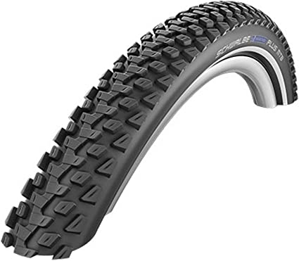
The new tires are great. I'm off road as much as on now. I did a nice loop on Saturday, not really planned out, which resulted in me riding several more miles due to missing a couple of turns. I was heading to Inspiration Point, which wasn't as inspirational once I arrived. It was somewhat crowded, and the view wasn't all that good at the lookout. I took the paved trail, that was pretty crowded with hikers, and a few bikes. Fortunately, once you get to the unpaved trails, it thins way out.
The first part of the dirt path caters to hikers, with several forks to take that end up at lookout points with benches. I took most of them, in addition to some single track paths off the main trail. After passing the second set of cattle gates, there are more cows than people, and the hills get steeper.

In general, the whole loop so far has been climbing, by around 1000 ft from my starting point, so although the other spot is call Inspiration Point, the views from the top of the ridge have the better views. The motor functioned well, and the bike climbed up a few 25%-30% trails pretty easily with the 3-position switch on low, with me pedaling of course.

The trail down was even steeper, but a good test for my new tires. :thumb:

A view inland; San Pablo Reservoir and Mount Diablo in the background.

The ride home is almost all downhill, with regen braking all the way, too. :lol: