El Niño in the newz. Again.

Actually got some rain this morning and then after sunset (just stopped short time ago). Neighbor's gauge says 0.13", there are puddles in the yard and lakes in the street.

Didn't have to ride to work or home in it, at least (was pretty chilly, and I'd forgotten my rain gear :( ).
 
We got more sprinkles last night after the above, off and on for a few hours.


Cleared up for the morning thru afternoon, then got rainy a bit here and there, and now been an actual thunderstorm with some serious lightning and bowling-alley-in-the-sky thunder, with few cannonades and a couple of wiggling two-man-treesaws, going on for about an hour so far, still raining fairly good the whole time; just started getting much heavier a minute ago. (rain radar shows the red and purple parts of the storm should be about right over me now).
 

Detailed Forecast​

This Afternoon
Sunny, with a high near 69. West wind around 5 mph.
Tonight
Mostly clear, with a low around 45. Calm wind becoming east around 5 mph.
Sunday
Mostly sunny, with a high near 68. Light and variable wind becoming southwest 10 to 15 mph in the morning. Winds could gust as high as 20 mph.
Sunday Night
Patchy fog after 10pm. Otherwise, partly cloudy, with a low around 43. Calm wind.
Monday
Patchy fog before 10am. Otherwise, partly sunny, with a high near 63. Southwest wind around 5 mph.
Monday Night
Patchy drizzle and fog after 10pm. Mostly cloudy, with a low around 44.
Tuesday
Patchy drizzle and fog before 10am. Partly sunny, with a high near 64.
Tuesday Night
Patchy drizzle and fog after 10pm. Mostly cloudy, with a low around 46.
Wednesday
Patchy drizzle and fog before 10am. Mostly sunny, with a high near 68.
Wednesday Night
Mostly clear, with a low around 45.
Thursday
Sunny, with a high near 67.
Thursday Night
Mostly clear, with a low around 46.
Friday
Sunny, with a high near 70.
 
Wrap around moisture is unpredictable but usually brings winds including microbursts and showers that can spill over the mountains from the east.
Not our normal weather pattern of storms coming from the ocean.
 
Last edited:
El Nino Rain Gage
Nothin'/Skunked-Foggy Doggy-Play Misty-Drizzle Corn-Light Showers-Steady Soaker-Bands/Sheets-Cats & Dogs
*****************************************************************************:)
 
Really nice weather the last week or so. The hills are all green from the rain. Probably won't last long.

1710643416539.png
 

Detailed Forecast​

Today
Partly sunny, with a high near 71. Light northwest wind becoming southwest 5 to 10 mph in the afternoon.
Tonight
Mostly cloudy, with a low around 48. South wind around 5 mph becoming calm in the evening.
Saturday
A chance of rain. Mostly cloudy, with a high near 55. Light southwest wind increasing to 10 to 15 mph in the morning. Winds could gust as high as 20 mph. Chance of precipitation is 50%. New precipitation amounts of less than a tenth of an inch possible.
Saturday Night
A chance of showers, with thunderstorms also possible after 11pm. Mostly cloudy, with a low around 43. Southwest wind 5 to 10 mph, with gusts as high as 20 mph. Chance of precipitation is 50%. New rainfall amounts of less than a tenth of an inch, except higher amounts possible in thunderstorms.
Sunday
Showers likely and possibly a thunderstorm. Mostly cloudy, with a high near 51. West wind 5 to 15 mph becoming north in the morning. Winds could gust as high as 25 mph. Chance of precipitation is 60%. New rainfall amounts between a tenth and quarter of an inch, except higher amounts possible in thunderstorms.
Sunday Night
A chance of showers before 11pm. Partly cloudy, with a low around 40. Chance of precipitation is 50%.
Monday
Mostly sunny, with a high near 62.
Monday Night
Mostly cloudy, with a low around 44.
Tuesday
Partly sunny, with a high near 64.
Tuesday Night
Partly cloudy, with a low around 46.
Wednesday
Partly sunny, with a high near 65.
Wednesday Night
A slight chance of showers. Mostly cloudy, with a low around 46.
Thursday
Mostly sunny, with a high near 65.
 
El Nino Rain Gage
Nothin'/Skunked-Foggy Doggy-Play Misty-Drizzle Corn-Light Showers-Steady Soaker-Bands/Sheets-Cats & Dogs
*****************************************************************************:)
0.14” so far today with more? to come?
 
Last edited:
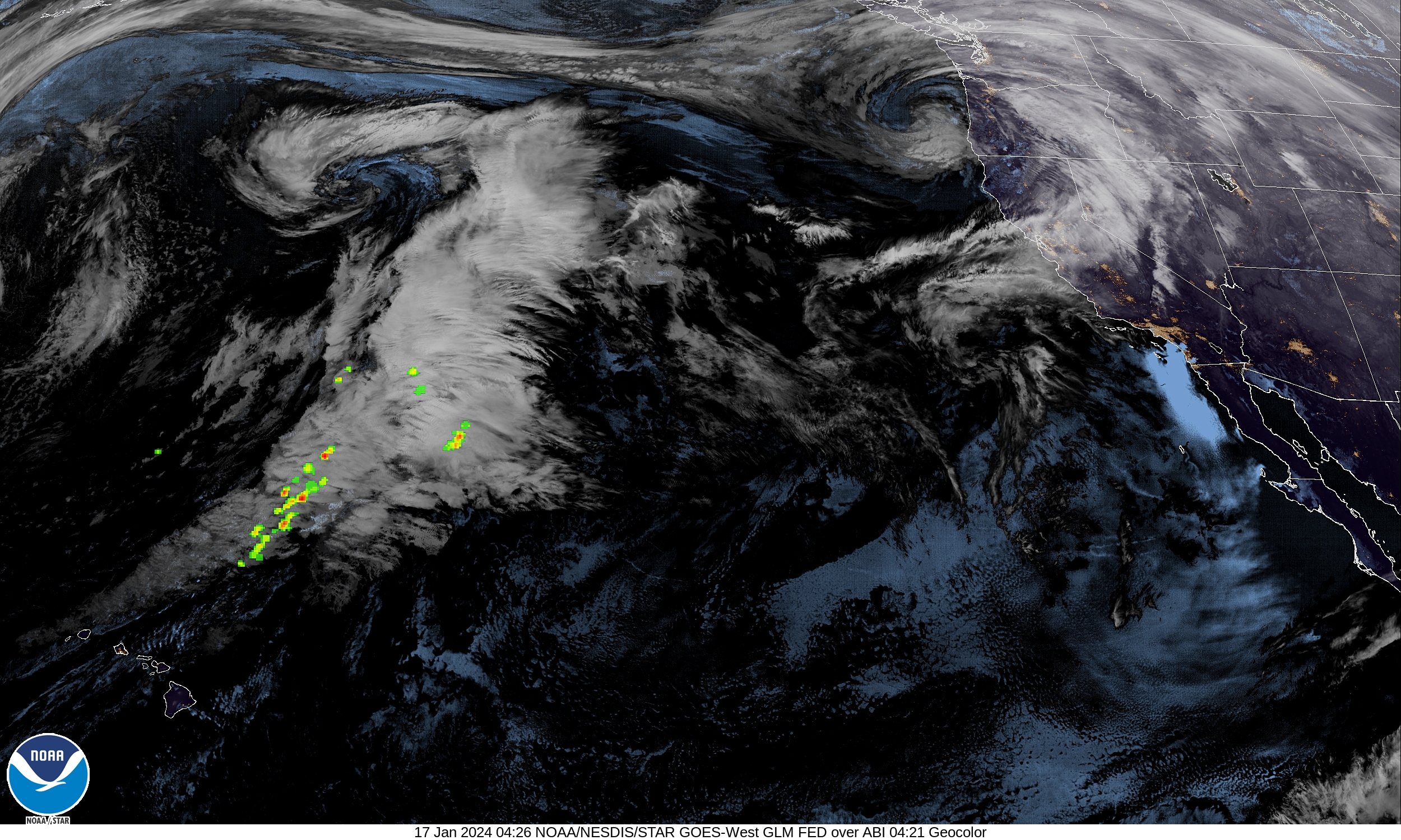
⚡️A little dry lightning strike here. Severe thunderstorm warning for LA County mountains.
Went out to roll the trash cart to the curb and looked. Big thunderstorm bearing down on us from the San Bernardino mountains this time. Dark rumbling continues and it also started to rain.
Edit:
So far the rain bands are missing us completely and the mountains surrounding here are getting snowed.
 
Last edited:
El Nino Rain Gage
Nothin'/Skunked-Foggy Doggy-Play Misty-Drizzle Corn-Light Showers-Steady Soaker-Bands/Sheets-Cats & Dogs
*****************************************************************************************************************************************:)
0.52” so far this morning as the front moves through.
 
Last edited:
With 1.5 inches in the last 2 days, we are now at 200% of our normal season average. I guess that is why they call it an average. 🤔
 
Last edited:
El Nino Rain Gage
Nothin'/Skunked-Foggy Doggy-Play Misty-Drizzle Corn-Light Showers-Steady Soaker-Bands/Sheets-Cats & Dogs
*********************************************************************************:)
0.32” this morning upped the storm total now to 1.43”.
 
Last edited:
Been drizzling and occasionally actually raining for about 6ish hours, about 0.36" so far per the neighbor's gauge. Supposed to continue the same thru tomorrow; we could use it.
 
Back
Top